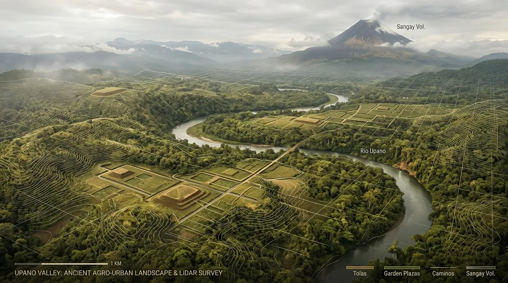
The Upano Valley and LiDAR Archaeology: The Garden Urbanism that Rewrote the Amazon
Table of contents7›
When observing the Amazon basin through the prism of contemporary science and technology, one of the most entrenched intellectual prejudices of Western historiography begins to disintegrate: the belief that the tropical rainforest was, prior to European arrival, a biologically exuberant yet culturally sterile green desert inhabited exclusively by small, nomadic foraging bands. In January 2024, a landmark study published in the journal Science by French archaeologist Stéphen Rostain (admired for his methodological perseverance across more than three decades of systematic excavations in the Ecuadorian Amazonian piedmont and for challenging the dogma of environmental determinism) demonstrated that, two millennia before the arrival of the conquistadors, the eastern lowlands of present-day Ecuador harbored the oldest, densest, and most extensive urban civilization ever discovered in the entire Amazon basin.
Empowered by airborne light detection and ranging (LiDAR) remote sensing, the French-Ecuadorian research team uncovered a dense network of integrated civic and residential centers, interconnected by monumental sunken roadways and agricultural canals that confound traditional definitions of forest habitation. These were neither isolated hamlets nor ephemeral encampments of wood and thatch, but a refined model of garden urbanism (urbanisme agraire) that thrived for over a millennium in the province of Morona Santiago.
Origins of the Enclave: Geography, Volcanism, and Shuar Roots
The Upano River valley lies on the eastern piedmont of the Ecuadorian Andes, nestled in an inter-Andean-Amazonian tectonic trough bounded to the west by the foothills of the Eastern Cordillera and to the east by the sub-Andean Cutucú range. At an elevation ranging between 700 and 1,100 meters above sea level, the valley enjoys a warm, humid transitional climate with annual rainfall frequently exceeding 3,500 millimeters.
In the ancestral worldview and toponymy of the indigenous Shuar people (Aents Chicham), who have inhabited the basin for generations, the waters of the Upano River—which converges with the Paute River to form the Namangoza, joining the Santiago and ultimately emptying into the mighty Marañón—constitute a sacred ecosystem governed by the tutelary forces of Arútam (the ancestral spirit of endurance) and the towering presence of the Sangay volcano (Kunguints in the native tongue).

This geography posed an ecological paradox that intrigued scientists for decades. Lowland Amazonian soils are overwhelmingly dominated by oxisols and ultisols: acidic clays hyper-leached by millennia of equatorial deluge, notoriously depleted of phosphorus, calcium, and essential nutrients. However, the Upano Valley enjoyed a decisive geological advantage: periodic explosive eruptions and ash plumes from the nearby Sangay volcano dusted the valley over millennia with mineral-rich volcanic tephra. This pedological process generated thick, fertile horizons of andosols—permeable, nutrient-dense volcanic soils that provided pre-Hispanic societies with an exceptional productive engine for the intensive cultivation of maize (Zea mays), manioc or cassava (Manihot esculenta), beans, and sweet potatoes.

Early archaeological evidence in the valley was initially documented in the late 1970s by Ecuadorian priest and archaeologist Pedro Porras Garcés, who excavated earthen mounds at the site of Huapula. However, the sheer density of the primary tropical forest obscured the broader landscape. Beginning in 1996, a collaborative French-Ecuadorian program directed by Stéphen Rostain (CNRS) and Antoine Dorison, working alongside Ecuador’s National Institute of Cultural Heritage (INPC), systematically excavated dozens of earthworks, cataloging finely crafted red-slipped ceramics with geometric incisions, subterranean clay baking ovens, and macrobotanical remains. Yet an optical instrument capable of piercing the canopy was sorely needed to map the complete territorial architecture at a landscape scale.
The Physics of the LiDAR Sensor: An Optical Scalpel Across the Forest Canopy
Amazonian archaeology historically encountered an intractable physical barrier: the multi-stratified tropical rainforest canopy, where tree crowns rising up to 30 meters high completely conceal ground relief from conventional aerial photography and optical satellite imagery.
The breakthrough in the Upano was unlocked through airborne LiDAR (Light Detection and Ranging) technology, mounted on a light aircraft that systematically surveyed a 300-square-kilometer transect of the valley:
- Pulse Emission: The laser scanner emits hundreds of thousands of coherently collimated light pulses per second in the near-infrared spectrum ($\lambda \approx 1064\text{ nm}$).
- Time-of-Flight Ranging: The range distance $d$ from the aircraft sensor to any reflective target is determined by measuring the round-trip transit time $\Delta t$ of the backscattered laser pulse, according to the fundamental relation: $$d = \frac{c \cdot \Delta t}{2}$$ where $c \approx 3 \times 10^8\text{ m/s}$ represents the propagation velocity of light through the atmosphere.
- Canopy Penetration and Multi-Return Scattering: A single laser footprint disperses across vegetation, yielding multiple returns: early echoes bounce off top canopy foliage; intermediate returns scatter off branches and lianas; but a vital remnant fraction (often less than $2\text{–}5%$) penetrates microscopic gaps between leaves to illuminate the bare ground directly before returning to the receiver.
- Algorithmic Filtering and DTM Generation: Employing progressive Triangulated Irregular Network (TIN) densification algorithms, processing software strips away non-ground vegetation returns. The resulting Digital Terrain Model (DTM) virtually denudes the surface topography with sub-meter spatial resolution and centimeter-scale vertical precision.
When the team rendered the processed Upano dataset, the featureless carpet of green foliage yielded to an astonishing anthropic landscape: thousands of hillocks long assumed to be natural hummocks revealed an uncompromising geometric choreography of rectangular platforms, graded thoroughfares, and perimeter defensive ditches.
Landscape Morphology: Platforms, Plazas, and Monumental Roadways
The cartographic inventory generated by LiDAR exceeded the boldest projections: across the surveyed area, researchers documented more than 6,000 monumental earthen platforms (tolas), organized across fifteen distinct settlement clusters exhibiting low-density agro-urban morphology.
                    ┌─────────────────────────┐
                    │     North Platform      │
                    │   (20 m x 10 m x 2 m)   │
                    └─────────────────────────┘
                                 │
     ┌──────────────────┐        ▼        ┌──────────────────┐
     │  West Platform   │   [Cent. Plaza] │  East Platform   │
     │                  │ ◄─── Open Air─► │                  │
     └──────────────────┘        ▲        └──────────────────┘
                                 │
                    ┌─────────────────────────┐
                    │     South Platform      │
                    │  (Dwelling / Workshop)  │
                    └─────────────────────────┘
                                 │
            ═════════════════════╪═════════════════════
                 Sunken Road (10-12 m in width)
            ═════════════════════╧═════════════════════
The valley’s built environment displays standardized modular units and coherent regional spatial planning:
- Habitation and Ceremonial Platforms: The overwhelming majority of the mounds are rectangular, with modal dimensions of approximately 20 meters in length by 10 meters in width and standing 2 to 3 meters above the surrounding grade. In paramount civic centers, such as Kilamope or Sangay, colossal earthen terraces reached up to 140 meters in length, 40 meters in width, and 8 meters in height, demanding the quarrying, transport, and hand-compaction of tens of thousands of cubic meters of clayey soil.
- Geometric Plaza Configurations: Platforms were never constructed haphazardly. They were consistently clustered in modules of three to six mounds surrounding a low, rectangular open-air plaza, where domestic chores, ceremonial assemblies, and artisanal craftsmanship transpired. Perishable superstructures of timber and thatch with gabled roofs stood atop the earthen foundations, shielding living quarters from ground dampness and terrestrial fauna.
- The Rectilinear Road Network: The most astonishing civil engineering feat is the network of sunken roads (chemins creux). These wide avenues were excavated straight into the clay subsoil, spanning 10 to 12 meters in width with flanking embankment cuts up to 3 meters deep. These avenues traverse the landscape in unrelenting straight trajectories over distances of up to 25 kilometers, linking discrete urban hubs without flinching before ravines or moderate terrain gradients.
- Hydraulic Civil Engineering and Cultivation Fields: Between residential nodes, LiDAR mapped a sophisticated system of drainage ditches and raised agricultural fields (champs surélevés). These channels evacuated excessive precipitation toward the tributaries of the Upano River, averting crop waterlogging and preventing slope erosion during equatorial downpours.
Chronology and Demographics: One Thousand Years of Continuous Settlement
Stratigraphic excavations and radiocarbon ($^{14}\text{C}$) dating conducted by Rostain’s team established a prolonged, multi-phased cultural chronology:
| Cultural Phase | Approximate Chronological Horizon | Core Characteristics |
|---|---|---|
| Kilamope Culture | c. 500 BCE – start of the Common Era | Initiation of mound construction; geometric red-painted domestic ceramics; early agronomic mastery of maize and manioc. |
| Upano Culture | c. 500 BCE – 300 / 600 CE | Architectural apogee; maximum expansion of the rectilinear sunken road grid; regional integration across major nodes (Sangay, Kilamope, Kunguints). |
| Occupational Hiatus | c. 600 CE – 800 CE | Cessation of monumental construction, tentatively linked to catastrophic eruptive activity of Sangay or regional sociopolitical reorganization. |
| Huapula Culture | c. 800 CE – 1200 CE | Reoccupation of pre-existing platforms; distinctive incised and slipped ceramics; residential reuse without commissioning massive new earthworks. |
Regarding demographic scale, conservative baseline estimates propose that during the zenith of the Kilamope and Upano phases, the valley supported between 15,000 and 30,000 residents simultaneously, while spatial density models accounting for the full extent of cultivated terraces indicate populations may have well exceeded 50,000 people. This demographic concentration places the Upano urban systems on an equal footing with Early Classic Maya lowland cities in the Petén or significant contemporary centers of the Greco-Roman Mediterranean.
Dismantling the “Counterfeit Paradise”: The Fall of Environmental Determinism
For over half a century, Western scholarship on Amazonian antiquity was tethered to the influential doctrine of environmental determinism, canonized by American anthropologist Betty Meggers in her seminal work Amazonia: Man and Culture in a Counterfeit Paradise (1971).

Meggers’ thesis asserted that tropical rainforest ecosystems constituted a deceptive biological trap: a veneer of luxuriant biomass masking fragile, nutrient-starved soils perpetually impoverished in bioavailable protein. Under this paradigm, the rainforest imposed an insurmountable “ecological glass ceiling” that precluded the emergence of complex statehood, monumental public works, or sedentary urbanism; any attempt at intensive agriculture would trigger catastrophic soil erosion, inevitably condemning Amazonian populations to fragmented tribal bands, nomadic migration, and shifting swidden foraging.
The empirical evidence from the Upano Valley completely refutes this determinist dogma:
- Environmental Sovereignty: The societies of the Upano were never passive prisoners of their ecology, but conscious stewards and architects of an anthropogenic landscape. They harmonized the volcanic fertility of Sangay with monumental hydraulic and transport engineering.
- Garden Urbanism vs. Stone Megalopolises: Unlike ancient Mesopotamian or Roman cities—defined by high-density stone and brick architecture sharply demarcated from rural agrarian hinterlands—the Amazonian paradigm was one of garden urbanism: an open, low-density fabric where residential platforms, civic plazas, and agrarian plots existed in a contiguous, ecologically sustainable equilibrium.
- Chronological Precociousness: Settled by 500 BCE, these complex societies were not a late or degenerate offshoot of the high Andean civilizations (such as Chavín, Tiwanaku, or the Incas), but an autonomous, contemporaneous civilizational cradle possessing its own distinct engineering, ceramic traditions, and cosmological vision.
The Scientific Legacy: A New Chapter in American Heritage
The rediscovery of the Upano urban networks marks a watershed moment for global archaeology and an enduring point of cultural pride for Ecuador. Dispelling colonialist fantasies of golden cities (El Dorado), the archaeological reality documented by Stéphen Rostain, Antoine Dorison, and their colleagues is infinitely more profound: a civilization anchored in the living earth, capable of marshaling millions of communal labor hours to sculpt earthworks and boulevards that endured across two thousand years.
Modern science has begun to right a long-standing historical injustice. The Ecuadorian Amazon can no longer be characterized as an untouched, virgin jungle awaiting European arrival, but as a crucible of ancient civilization where civil engineering, volcanic soil management, and forest coexistence forged one of the most remarkable chapters of pre-Columbian history.
Sources and Recommended Reading
- Rostain, S., Dorison, A., et al. (2024). Two thousand years of garden urbanism in the Upper Amazon. Science, Vol. 383, Issue 6679, pp. 183–189
Original peer-reviewed study presenting the airborne LiDAR data, excavation stratigraphy, typology of earthen mounds, and radiocarbon chronology in the Upano Valley. - Wikipedia (Spanish): Yacimientos arqueológicos del valle de Upano
Comprehensive overview of the geographic setting, cultural sequence (Kilamope, Upano, Huapula), and field research history in Morona Santiago. - Wikipedia (English): Upano Valley sites
Detailed monograph examining the mound morphology, road networks, laser remote sensing methodology, and theoretical implications for Amazonian archaeology. - Smithsonian Magazine: Vast Network of Ancient Cities Discovered in the Amazon Rainforest
In-depth journalistic coverage detailing the discovery by the French-Ecuadorian team, its paradigm shift against environmental determinism, and interviews with the authors. - Wikipedia (Spanish): Volcán Sangay
Geological and volcanic context of the active stratovolcano in Morona Santiago whose tephra enriched the agricultural andosols of the Upano basin.