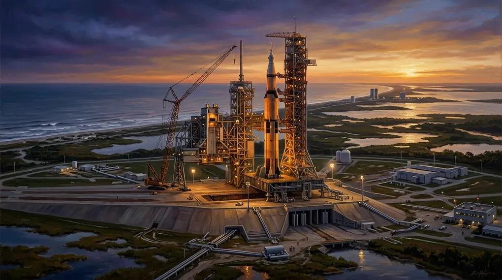
Spaceports: The Sacred Geography of Orbital Mechanics and Earth’s Gateways to the Cosmos
Table of contents6›
In my readings on astrodynamics and astronautics, few engineering monuments merge poetic ambition and physical rigor quite like spaceports (admired for serving as the sole terrestrial thresholds capable of converting chemical energy into orbital velocity and opening the pathways of the cosmos to humanity), true architectural sanctums where the geography of Earth bends before the universal laws of Johannes Kepler and Isaac Newton.
To a casual onlooker, an orbital rocket appears merely to lift off “upward,” striving to punch vertically through the dense soup of the atmosphere. Yet in the unforgiving geometry of orbital spaceflight, altitude is merely a secondary requirement; the essential challenge is horizontal tangential speed. To avoid plunging back into the planetary crust, a vehicle must reach the first cosmic velocity ($v_1 \approx 7.8,\text{km/s} \approx 28,000,\text{km/h}$ in Low Earth Orbit), continuously falling around the curved horizon of Earth without ever touching it.
As the Russian visionary Konstantin Tsiolkovsky (Константин Циолковский) (admired for formulating the ideal rocket equation when aviation was still in its infancy) wrote in the early twentieth century: «Земля — колыбель человечества, но нельзя вечно жить в колыбели» (Zemlyá — kolybel’ chelovéchestva, no nel’zyá véchno zhit’ v kolybeli, “Earth is the cradle of humanity, but one cannot live in the cradle forever”). Spaceports are the coastal and desert quays from which that cradle is first cast off.
Historical Origins: From Military Test Ranges to the Steppes of Tyuratam
The modern spaceport did not originate within peaceful university campuses or astronomical observatories, but across the proving grounds of long-range ballistic artillery during the early Cold War.
Its direct technological precursor was established in 1936 along the Baltic Sea coastline of Germany: the Army Research Center at Peenemünde (Heeresversuchsanstalt Peenemünde), on the island of Usedom. Rocket engineer Wernher von Braun (1912–1977) deliberately selected this coastal promontory because it allowed experimental launches of the A-4 rocket (later designated the V-2) to traverse more than three hundred kilometers over open Baltic waters without endangering civilian populations, while allowing optical telemetry and radar tracking stations to be stationed across neighboring islands.
Following the close of World War II, both the United States and the Soviet Union initially transferred their missile testing to inland desert firing ranges: White Sands in New Mexico and Kapustin Yar (Капустин Яр) near the lower Volga River. However, as intercontinental ballistic missiles (ICBMs) surpassed ranges of one thousand kilometers, both superpowers realized that orbital staging demanded an entirely different territorial canvas.
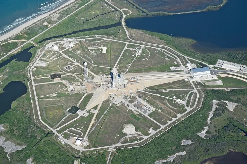 Aerial view of Launch Complex 39A (LC-39A) at Kennedy Space Center, Florida, showing the massive concrete flame trench and pad facing eastward toward the Atlantic Ocean (Credit: NASA).
In the United States, geographic surveys in 1949 identified a sandy, marshy barrier spit along Florida’s Atlantic seaboard: Cape Canaveral (temporarily named Cape Kennedy between 1963 and 1973). The peninsula possessed two decisive advantages:
- A southerly latitude for the contiguous United States ($\approx 28.5^\circ,\text{N}$), which harnessed a substantial portion of Earth’s rotational momentum.
- An unobstructed eastward launch corridor spanning thousands of nautical miles across the open Atlantic Ocean (Eastern Range), mitigating civilian casualties during ascent failures while accommodating tracking stations across the Bahamas and the West Indies. In the 1960s, to house the Saturn V super heavy-lift rocket for the Apollo lunar program, NASA acquired the adjacent acreage of Merritt Island, establishing the John F. Kennedy Space Center (KSC).
In the Soviet Union, geographic reality presented far harsher constraints. Lacking ice-free eastern shorelines at temperate or tropical latitudes, the technical commission steered by Chief Designer Sergei Pavlovich Korolev (Сергей Королёв) (admired for his extraordinary organizational fortitude and technological vision in realizing humanity’s first artificial satellite and crewed orbital flight) selected in January 1955 a remote semidesert expanse in the Kazakh Soviet Socialist Republic, situated beside the isolated railway station of Тюра-Там (Tyuratam, “Tyura’s tomb”).
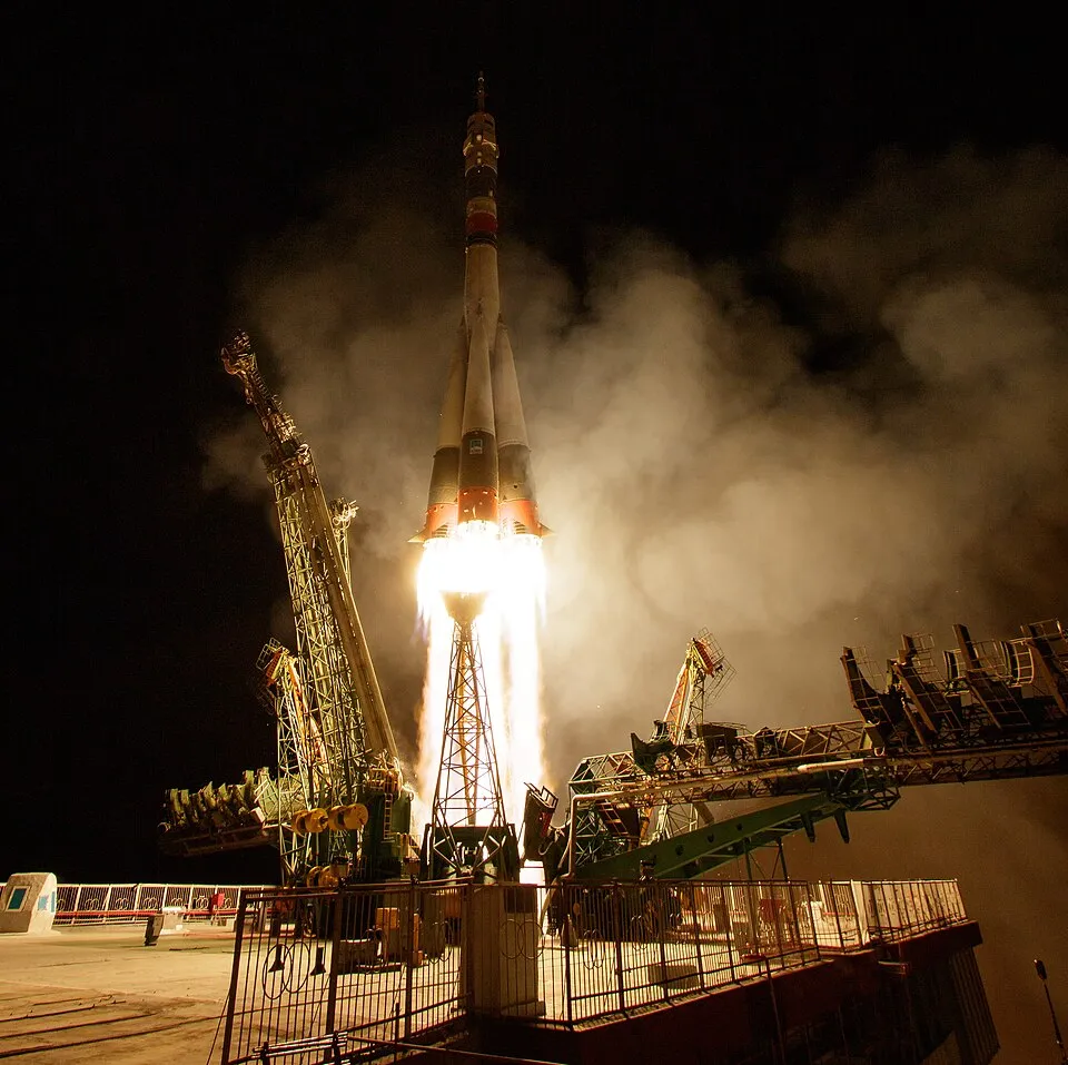 The historic Site 1/5 (“Gagarin’s Start”) at the Baikonur Cosmodrome, Kazakhstan, prior to the rollout of the Soyuz MS-15 spacecraft (Credit: NASA / Bill Ingalls).
To preserve military secrecy against Western aerial reconnaissance, Soviet intelligence assigned the complex the deceptive designation of Байконур (Baikonur, a Kazakh place name evoking “fertile clover pasture”), an actual mining village situated more than three hundred kilometers northeast of the real installation. Tyuratam offered direct connectivity to the Moscow-Tashkent railway for horizontal train transport of rockets, the waters of the Syr Darya river for industrial cooling, more than three hundred cloudless days per year, and thousands of kilometers of unpopulated steppe to the east for spent booster stage drop zones. It was here that Site 1 (Ploshchadka 1) was erected—the celebrated pad known today as “Gagarin’s Start” (Gagarinskiy Start, Гагаринский старт), which sent forth both Sputnik 1 in 1957 and Yuri Gagarin on Vostok 1 in 1961.
The Physics of Launch Latitude: Why Geometry Dictates Destiny
The location of a spaceport is never an arbitrary political choice; it is bound by the inexorable geometry of celestial mechanics. Three fundamental principles govern the efficiency, energy budget, and payload capacity of any launch site:
1. The Rotational Kinematic Boost of Earth
Earth rotates on its polar axis from west to east with a constant angular velocity:
$$\omega \approx 7.292115 \times 10^{-5},\text{rad/s}$$
At any point on Earth’s surface located at latitude $\phi$, the effective orbital radius relative to the rotational axis is $r(\phi) = R_{\oplus} \cos \phi$, where $R_{\oplus} \approx 6,378,\text{km}$ denotes the equatorial radius of the geoid. Consequently, the linear tangential surface speed imparted by planetary rotation is given by:
$$v_{\text{rot}}(\phi) = \omega R_{\oplus} \cos \phi$$
Evaluating this equation across prominent launch facilities reveals a stark energy divide:
| Spaceport | Country / Operator | Latitude ($\phi$) | Tangential Speed ($v_{\text{rot}}$) | Percentage of Equatorial Boost |
|---|---|---|---|---|
| Equator | — | $0^\circ$ | $465.1,\text{m/s}$ ($1,674,\text{km/h}$) | $100.0%$ |
| Kourou (CSG) | France / ESA | $5.23^\circ,\text{N}$ | $463.2,\text{m/s}$ ($1,667,\text{km/h}$) | $99.6%$ |
| Alcântara (CLA) | Brazil | $2.31^\circ,\text{S}$ | $464.7,\text{m/s}$ ($1,673,\text{km/h}$) | $99.9%$ |
| Tanegashima | Japan (JAXA) | $30.40^\circ,\text{N}$ | $401.1,\text{m/s}$ ($1,444,\text{km/h}$) | $86.2%$ |
| Cape Canaveral (KSC) | United States (NASA) | $28.50^\circ,\text{N}$ | $408.7,\text{m/s}$ ($1,471,\text{km/h}$) | $87.9%$ |
| Baikonur | Kazakhstan / Russia | $45.92^\circ,\text{N}$ | $323.7,\text{m/s}$ ($1,165,\text{km/h}$) | $69.6%$ |
| Plesetsk | Russia | $62.92^\circ,\text{N}$ | $211.7,\text{m/s}$ ($762,\text{km/h}$) | $45.5%$ |
When a rocket launches directly eastward (in a prograde trajectory), it inherits this tangential velocity free of charge as its initial state vector. For Kourou, this delivers an inherent bonus of $463,\text{m/s}$, whereas for Baikonur the assist drops to $324,\text{m/s}$. That difference of $\approx 140,\text{m/s}$ in the total delta-v ($\Delta v$) budget compounds exponentially through the Tsiolkovsky rocket equation ($\Delta v = v_e \ln(m_0 / m_f)$), translating into hundreds of kilograms of structural propellant that higher-latitude vehicles must burn simply to match what equatorial nature provides for free.
2. The Minimum Inclination Law ($i \ge |\phi|$)
A core theorem of Keplerian orbital mechanics dictates that the orbital plane of any satellite must pass through Earth’s center of mass and the geographical launch coordinates at the exact instant of orbital injection.
As a direct geometric consequence, the minimum orbital inclination ($i_{\min}$) accessible via a direct launch—without executing a plane-change maneuver—equals the absolute value of the launch site’s latitude:
$$i \ge |\phi|$$
Launching due east ($\beta = 90^\circ$) yields an orbital inclination exactly equal to the site’s latitude: $i = \phi$. Any departure in azimuth to the northeast or southeast increases the resulting inclination according to spherical trigonometry:
$$\cos i = \cos \phi \sin \beta$$
This law poses severe challenges for geostationary telecommunications satellites (GEO), which must operate in an equatorial plane ($i = 0^\circ$) at an altitude of $35,786,\text{km}$ to remain motionless relative to a terrestrial ground station.
A booster lifting off from Cape Canaveral ($\phi = 28.5^\circ$) enters an initial orbit inclined at least $28.5^\circ$. To nullify this inclination and align the satellite with the equator, the upper stage engine must perform a plane-change burn at orbital apogee:
$$\Delta v_{\text{plane}} = 2 v \sin\left(\frac{\Delta i}{2}\right)$$
Where $v$ is the velocity at the maneuver node and $\Delta i$ is the required angular inclination shift. In a Geostationary Transfer Orbit (GTO), where apogee speed is roughly $v_{\text{ap}} \approx 1,600,\text{m/s}$, eliminating Cape Canaveral’s $28.5^\circ$ inclination requires expending approximately $\Delta v \approx 787,\text{m/s}$ of precious fuel. Conversely, launching from Kourou ($\phi = 5.2^\circ$) requires eliminating only $\Delta i = 5.2^\circ$, demanding merely $\Delta v \approx 145,\text{m/s}$.
This commanding mechanical advantage explains why the Guiana Space Centre (Centre Spatial Guyanais, CSG) in Kourou became the premier commercial spaceport for geostationary payloads and flagship deep-space observatories, such as the James Webb Space Telescope (JWST), which lifted off aboard an Ariane 5 rocket on December 25, 2021.
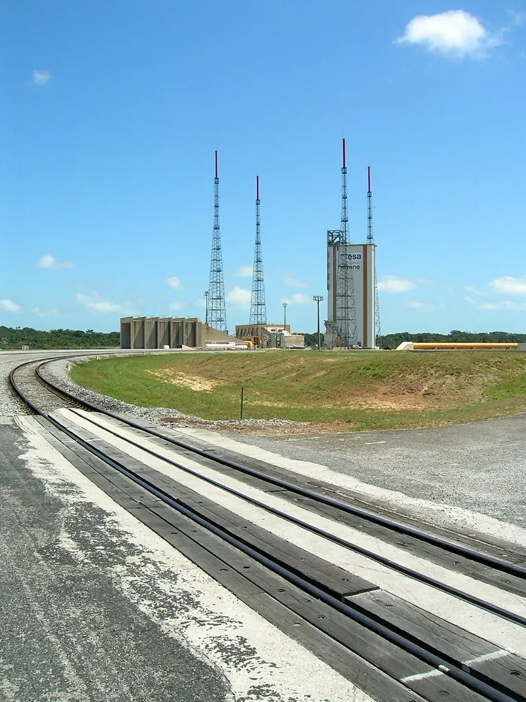 Ariane launch pad and infrastructure at the Centre Spatial Guyanais (CSG) in Kourou, French Guiana (Credit: ESA / CNES).
3. The Geopolitical Corridor of the International Space Station ($51.6^\circ$)
The $51.6^\circ$ orbital inclination of the International Space Station (ISS) represents one of the most remarkable geopolitical compromises in modern engineering.
From a purely American propellant perspective, the ISS should have been placed at $28.5^\circ$ to match the latitude of Kennedy Space Center, maximizing the Space Shuttle’s payload capacity. However, following the collapse of the Soviet Union in 1991, NASA and the newly formed Roscosmos agreed to merge the planned Russian Mir-2 space station with the Western Freedom project.
For Russian Soyuz crew vehicles and Progress resupply ships launched from Baikonur ($\phi = 45.9^\circ,\text{N}$) to rendezvous with the station without costly orbital plane changes, the station’s inclination had to be at least $45.9^\circ$. Yet Baikonur cannot launch due east ($\beta = 90^\circ$, which would give $i = 45.9^\circ$) because discarded first-stage booster strap-ons would impact within the borders of the People’s Republic of China. To ensure safe jettison over the desolate steppes of Kazakhstan and central Russia, Russian boosters must track a launch azimuth of $\beta \approx 64^\circ$, which yields an orbital inclination of precisely $51.6^\circ$. NASA agreed to sacrifice substantial Space Shuttle lift capacity on every single flight to enable shared access for both spacefaring superpowers.
Anatomy of a Launch Pad: Where Concrete Resists the Inferno
Far from a simple slab of tarmac, a modern orbital launch pad is a monumental feat of civil, thermal, and acoustic engineering, configured to survive stresses that would vaporize ordinary steel structures within fractions of a second:
-
The Flame Trench and Exhaust Deflector (Flame Trench / Газоотражатель): At ignition, a multi-engine orbital rocket expels tens of thousands of kilonewtons of thrust at temperatures surpassing $3,000,^\circ\text{C}$ and supersonic exhaust velocities exceeding $2,500,\text{m/s}$. Were this plasma plume to strike a flat floor, the reflected gas shockwaves would bounce upward into the engine bells, destroying the vehicle in tenths of a second. The flame trench, excavated dozens of meters deep and lined with refractory ceramic alloys and heavy-density concrete, funnels the plume onto a double-sided wedge deflector that turns the torrent ninety degrees into open drainage basins.
-
Sound Suppression Water Deluge System: During liftoff, the primary threat to the vehicle is frequently not thermal energy, but acoustic vibration. Massive turbulent combustion generates sound power levels exceeding 210–220 decibels (dB). At this threshold, acoustic waves cease to behave as audible sounds and transform into physical barometric shock fronts capable of shearing structural rivets, denting engine skirts, and shattering satellite payload optics. To counteract this destructive energy, elevated water towers release hundreds of thousands of liters of water per minute directly into the trench and pad deck in the final seconds of countdown. The water droplets absorb the acoustic shockwaves through momentum transfer and instantaneous thermal phase change (flash evaporation), dissipating the acoustic energy into immense plumes of billowy white steam.
-
Cryogenic Umbilical Towers and Quick-Disconnect Arms: An orbital rocket sits fueled with thousands of metric tons of liquid oxygen ($\text{LOX}$, $-183,^\circ\text{C}$) and liquid hydrogen ($\text{LH}_2$, $-253,^\circ\text{C}$) or liquid methane ($\text{LCH}_4$, $-162,^\circ\text{C}$). Because these cryogenic liquids boil off continuously, replenishment lines must remain pressurized until the final fractions of a second before flight, detaching through pyrotechnically actuated quick-disconnect plates or counterbalanced swing arms the instant the hold-down clamps release.
Global Enclaves: An Atlas of Strategic Spaceports
Over the decades, international geography has given rise to specialized spaceports tailored to distinct tactical and orbital missions:
- Vandenberg Space Force Base (California, $\approx 34.7^\circ,\text{N}$): Perched on a coastal promontory along the southern California shore, Vandenberg is the Western gateway to polar orbits. Facing open ocean southward toward Antarctica with no inhabited landmasses along its ascent track, it accommodates launch azimuths from $140^\circ$ to $201^\circ$, inserting reconnaissance, Earth-observation, and weather satellites into Sun-synchronous orbits (SSO), where the spacecraft crosses each latitude at the identical mean solar time.
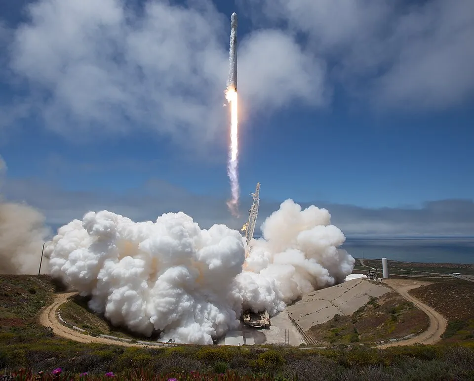 Liftoff of a Falcon 9 rocket from Space Launch Complex 4E (SLC-4E) at Vandenberg Space Force Base, California, arcing southward into polar orbit over the Pacific Ocean (Credit: NASA / Bill Ingalls).
- Tanegashima Space Center (種子島宇宙センター - Tanegashima Uchū Sentā, Japan, $\approx 30.4^\circ,\text{N}$): Widely considered the most visually striking spaceport on Earth, its launch complexes are set atop emerald bluffs and coral cliffs overlooking the Pacific Ocean in Kagoshima Prefecture. Established by JAXA to address the dense population of mainland Japan, its operational windows have historically been negotiated around local fishing union agreements to protect maritime livelihoods.
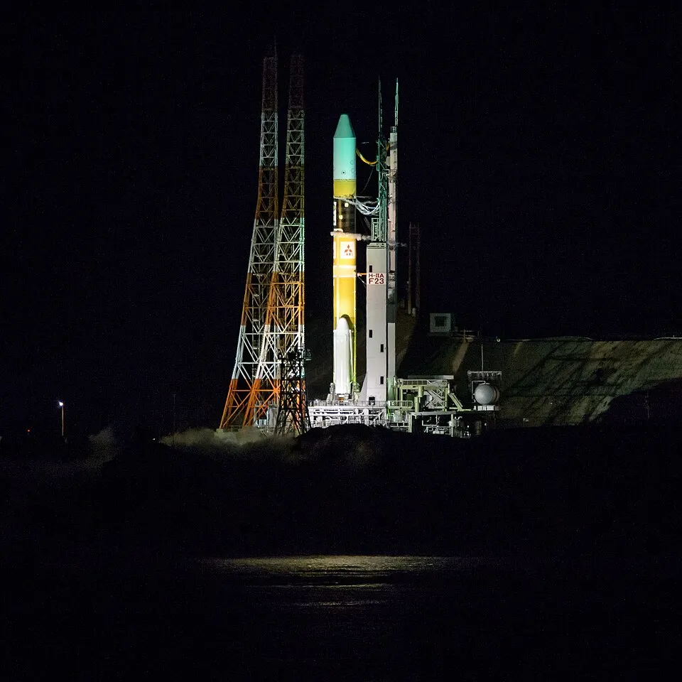 The H-IIA launch vehicle on the pad at the Yoshinobu Launch Complex, Tanegashima Space Center, Japan, set atop coastal bluffs overlooking the Pacific Ocean (Credit: NASA / Bill Ingalls).
- Jiuquan Satellite Launch Center (酒泉卫星发射中心 - Jiǔquán Wèixīng Fāshè Zhōngxīn, China, $\approx 40.9^\circ,\text{N}$): Constructed deep within the Gobi Desert, Jiuquan is the venerable cradle of China’s human spaceflight program (Shenzhou). Although its inland trajectories mean spent rocket stages fall over remote interior land areas, its continental setting provided the shielded isolation necessary for the early Long March (长征) rocket series.
- Mahia Launch Complex 1 (Rocket Lab, New Zealand, $\approx 39.2^\circ,\text{S}$): Located on the Mahia Peninsula of New Zealand’s North Island, this facility inaugurated the modern era of private orbital spaceports in 2017. Benefiting from exceptionally low maritime and aviation traffic corridors, it sustains a remarkably agile launch cadence for the Electron small-satellite booster.
The Future: From Catch Towers to Orbital Docks
The fundamental architecture of the spaceport is undergoing its most radical reimagining since the dawn of the Apollo era.
Along the shores of the Gulf of Mexico at Boca Chica, Texas, Starbase has dismantled traditional paradigms of horizontal assembly and crawlerway transport. Centered around an immense steel launch-and-integration tower equipped with articulated mechanical arms (Mechazilla), the complex is designed not merely to launch the Starship / Super Heavy architecture, but to catch the returning seventy-meter booster mid-air as it descends propulsively back to the pad.
Concurrently, interest in floating mobile maritime spaceports has rekindled. Semisubmersible vessels—proven in the 1990s and 2000s by the international Sea Launch consortium—demonstrated that towing an offshore drilling platform to international waters at the exact geographic equator ($0^\circ$) unlocks the maximal $465,\text{m/s}$ rotational boost while eliminating populated downrange hazard constraints entirely.
Across the coming decades, spaceports will gradually emancipate themselves from Earth’s soil. The establishment of orbital cryogenic propellant depots in Low Earth Orbit (LEO) and transshipment stations at the Earth-Moon Lagrange points ($L_1$ and $L_2$) will redefine interplanetary transit: deep-space expeditions will no longer need to drag all their fuel out of Earth’s heavy gravitational well in a single launch, departing instead from quiet space docks in the void.
Until that frontier arrives, these terrestrial bastions—surrounded by the brackish lagoons of Florida, the humid rainforests of Guiana, or the bitter winds of the Kazakh steppe—will remain the great harbors of our civilization: the exact geography where human intellect, armed with calculus and thermodynamics, transforms the dust of Earth into vessels sailing toward the stars. Per aspera ad astra.
Documentary Sources and References
- National Aeronautics and Space Administration (NASA): Kennedy Space Center History and Launch Complexes Overview. nasa.gov/kennedy
- European Space Agency (ESA): Europe’s Spaceport: Strategy, Geography and Facilities in French Guiana. esa.int/Space_Transportation/Europe_s_Spaceport
- Centre National d’Études Spatiales (CNES): Le Centre Spatial Guyanais (CSG): Port spatial de l’Europe. cnes.fr/en
- Japan Aerospace Exploration Agency (JAXA): Tanegashima Space Center: Overview and Launch Facilities. global.jaxa.jp/about/centers/tnsc
- Bate, Roger R., Mueller, Donald D., & White, Jerry E.: Fundamentals of Astrodynamics. Dover Publications, New York, 1971.
- Curtis, Howard D.: Orbital Mechanics for Engineering Students. Butterworth-Heinemann, Elsevier Aerospace Engineering Series, Oxford, 4th edition, 2020.
- Siddiqi, Asif A.: Challenge to Apollo: The Soviet Union and the Space Race, 1945–1974. NASA History Series, NASA SP-2000-4408, Washington D.C., 2000. nasa.gov/history